Chesapeake Bay Interpretive Buoy System
The National Oceanic and Atmospheric Administration's buoy system brings the Bay into the palm of your hand
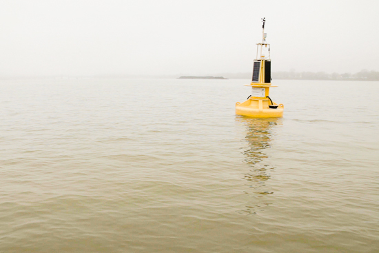
Warm weather is upon us, and that means people will be taking to the water to escape from the heat. Soon enough, the Chesapeake Bay will be dotted with bobbing watercrafts of all shapes and sizes. For those recreating on the Bay, the bright yellow Chesapeake Bay Interpretive Buoy System (CBIBS) markers may be a familiar sight, but they serve as much more than eye-catching aquatic beacons: they provide key insights into the health and safety conditions of the Bay.
The first buoys were deployed by the National Oceanic and Atmospheric Administration's (NOAA) Chesapeake Bay Office in 2007—marking 10 locations along the Captain John Smith Chesapeake Historic Trail—and have been collecting and transmitting real-time water quality and atmospheric data ever since. “It’s [the buoy system] interpretive because we work with the National Park Service as a partner to interpret John Smith’s trail, so there is a bit of a historical aspect to it,” said Katie Kirk, Senior Buoy Specialist at Earth Resources Technology, a contractor that supplies support staff and assistance to NOAA and other government agencies.
“Our main mission is to keep the 10 buoys that we have up and alive and transmitting as often as we can and deliver the data to as many users as we can,” said Kirk in reference to her and the field team’s work. Routine maintenance and repairs on the buoy fleet presents a swath of challenges that keeps the small team of CBIBS buoy technicians busy year-round.

The life of a CBIBS buoy technician differs from day-to-day and can be a physically demanding profession. Some days are spent in their Annapolis, Md., warehouse—affectionately referred to as the ‘buoy spa’—calibrating instruments, cleaning buoys, swapping out parts and working with computer systems. Other times, the team braves the wind, waves and elements to do onsite repairs and buoy maintenance.
As the summer and fall wind down and cold weather approaches, the team removes the three northernmost buoys from the Patapsco, Susquehanna and Upper Potomac rivers before freezing conditions set in to prevent ice damage. But this winter, the southern buoys succumbed to the frigid conditions: wind gusts exceeding 50 miles-per-hour and below-freezing water temperatures caused ice from sea spray to accumulate on and topple over the buoys, something the CBIBS team had never seen before. “The buoys that were off location tipped over, cracked and no longer had power, so we couldn’t track them on the GPS to figure out where they were. That was a pretty intense time trying to figure out where the buoys had moved to and how we could get to them,” explained Kirk.

After winter, the team’s short-term goals were to get all of the buoys repaired, online and transmitting data. With that completed, Kirk is now striving to see the data being analyzed and produced in scientific papers. “It’s been done before, but I want to get back to that and try to reach out to more teachers and researchers and see if they want more buoys or buoys in different locations,” Kirk said. “Then we can take the time and think about how our system reaches out to those users, what they need from us and what they would prefer.”
While many people accessing the data are local sailors and kayakers looking for information on the wind speed, currents, wave heights and local conditions before venturing out on the water, educators also integrate the data into their curriculum. Utilizing the data for educational purposes is of utmost importance to NOAA, so much so that they have an entire education team dedicated to reaching out to local schools to demonstrate how the CBIBS data can be used in the classroom.
In addition to live reporting of local water and weather conditions, the buoy data provides a snapshot into what is happening around the Bay, demonstrating in a quantitative way how each part of the ecosystem is interrelated. Information on water temperature, salinity and dissolved oxygen can help researchers uncover important linkages between water quality and blue crab stocks, fish populations, bay grass abundance and more.
Despite the many challenges that the buoy technicians face, Kirk and her team exude an air of passion and commitment to maintaining the instruments that provide the most up-to-date information about the state of the Bay, all in the name of presenting the best science. For those working to restore the estuary and those interested in learning about the issues the Bay faces, the data can serve as a useful tool.
“I think we have an amazing opportunity to protect this watershed and this bay,” said Kirk. “It goes back to resources and taking pride in where you live. This is your home, why wouldn’t you protect it?”
All of the data is free to the public and can be accessed online, by phone at (877) 286-9229 and via a mobile app.
To view more photos, visit the Chesapeake Bay Program’s Flickr page.
Video and images by Will Parson
Text by Jenna Valente
Comments
There are no comments.
Thank you!
Your comment has been received. Before it can be published, the comment will be reviewed by our team to ensure it adheres with our rules of engagement.
Back to recent stories