Six free apps to help you explore the Chesapeake Bay region
Explore the world from the palm of your hand with these nature-related apps

Smartphones are becoming a normal—if not essential—part of our everyday lives. From listening to music, ordering takeout, playing games or taking pictures of our pets, it seems like we’ve developed an app for everything. Even though our world is becoming much more digital, there are apps that can help get you outside and introduce you to the natural world. We’ve put together a list of six apps that can help you discover the Chesapeake Bay region.

1. Chesapeake Explorer
Developer: National Park Service
Available on: iTunes, Google Play
The Chesapeake Bay region is huge—over 64,000 square miles—and teeming with beautiful landscapes, fascinating history and a rich cultural heritage. There’s a lot of territory to cover and a lot to do within it, and that’s where the Chesapeake Explorer app comes in handy. Created by the National Park Service, Chesapeake Explorer allows you to easily find something to do no matter your interest. You can search by activity, such as hiking, biking or kayaking, or if you want to visit a museum or state park, you can search by place. If you want to stay local, you can use Chesapeake Explorer’s map feature to find out which sites are nearby. The app makes vacation planning easy as well, offering pre-set driving, biking and walking tours, and even allows you to create your own route. Whether you’re trying to fill an hour or a whole weekend, Chesapeake Explorer has something for you to do.

2. Audubon Birds of North America
Developer: National Audubon Society
Available on: iTunes, Google Play, Amazon
Audubon’s field guide to North American birds is the perfect one-stop app for birders of all feathers, from beginners to expert. This app is full of information for 821 bird species, including their appearances, behaviors, calls and ranges. It has a detailed search feature, allowing you to describe characteristics of the bird you see—plus, you can include your location to narrow your results to include only regional birds. You can even separate your search results into common and rare species, if you’re torn between the two. For those new to birding, or those who’d like a refresher, the app contains a lot of supplemental information about birding, bird families, bird anatomy and conservation.

3. Merlin Bird ID
Developer: Cornell University
Available on: iTunes, Google Play
The Merlin Bird ID app is another great choice for birdwatching. By answering five simple questions, Merlin helps you identify which bird you are likely looking at. Containing thousands of photographs and audio recordings, as well as identification tips and range maps for each bird, Merlin is a clear and simple app that makes bird identification easy.

4. Project Noah
Developer: Networked Organisms
Available on: iTunes, Amazon
Project Noah is a great way to get outside and involved in citizen science. With this app you can photograph wildlife in your area, tag the photos and upload them to the Noah website, where they’re combined with other sightings from around the world. One of the things that makes Project Noah so fun is that you can join missions—such as documenting squirrels—and earn patches as you contribute. Don’t worry if you don’t know the name of a species you see; you can always upload the photo and whatever information you have so that the rest of the Project Noah community can identify it (or you can check your field guide app!).

5. SkyView Free
Developer: Terminal Eleven LLC
Available on: iTunes, Amazon
SkyView is a simple tool to introduce you to the stars. As you move your phone along the night sky, information about stars and planets will show up on your screen, including outlines of the constellations. You can also switch the display to night vision with red light, so the screen’s light doesn’t hurt your eyes.
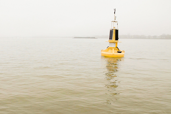
6. NOAA Smart Buoys
Developer: NOAA Chesapeake Bay Office
Available on: iTunes, Google Play
Looking for real-time, on-the-water observations from across the Bay? The NOAA Chesapeake Bay Office’s Smart Buoys app allows users to track data from the ten buoys that make up the Chesapeake Bay Interpretive Buoy System (CBIBS). Get a snapshot of safety conditions in the Bay before heading out on the water, explore the science behind the health of the estuary or track how storms and weather events are affecting water conditions.
What apps do you use to explore the Chesapeake Bay? Tell us your favorite in the comments!
Comments
There are no comments.
Thank you!
Your comment has been received. Before it can be published, the comment will be reviewed by our team to ensure it adheres with our rules of engagement.
Back to recent stories