Geology
Travel back to when the Chesapeake Bay was first formed to learn about the geologic history of the region.
For thousands of years, the Chesapeake Bay has been changing continuously. Some changes are sudden, whereas others take place over such a long period of time that we can only see them by looking back into geologic history. All geologic changes affect the Bay ecosystem, for better or worse.
Geologic history of the Chesapeake Bay
Bolide
About 35 million years ago, a rare bolide—a comet- or asteroid-like object from space—hit the area that is now the lower tip of the Delmarva Peninsula, near Cape Charles, Virginia. The bolide created what geologists call the “Exmore Crater,” which they believe was as large as Rhode Island and as deep as the Grand Canyon. This bolide did not create the Chesapeake Bay, but it helped determine that a bay would eventually be located there.
Ancient Susquehanna River Valley
During the last Ice Age, mile-thick glaciers stretched as far south as Pennsylvania, and the Atlantic coastline was about 180 miles farther east than it is today. Approximately 18,000 years ago, the glaciers began to melt, carving streams and rivers that flowed toward the coast. The sea level continued to rise, eventually submerging the area now known as the Susquehanna River Valley. This drowned river valley became the Chesapeake Bay.
The Chesapeake Bay assumed its present shape about 3,000 years ago. Remnants of the ancient Susquehanna River still exist today as a few troughs that form a deep channel along much of the bottom of the Bay.
Watershed geology
To fully define the Chesapeake Bay ecosystem, we must go far beyond its shores. Although the Bay itself lies entirely within the Atlantic Coastal Plain, its watershed includes parts of the Piedmont Plateau and Appalachian Province. The waters that flow into the Bay have different chemical identities depending on the geology of where they originate.
Atlantic Coastal Plain
The Atlantic Coastal Plain is a flat, lowland area with a maximum elevation of about 300 feet. It is supported by a bed of crystalline rock covered with southeasterly dipping wedge-shaped layers of sand, clay, and gravel. Water passing through this loosely compacted mixture dissolves many of the minerals. The most soluble elements are iron, calcium, and magnesium.
The coastal plain extends westward from the continental shelf to a fall line that ranges from 15 to 90 miles west of the Bay. Waterfalls and rapids clearly mark this line, which is close to Interstate 95. Cities like Baltimore, Maryland; Washington, D.C.; and Richmond, Virginia, were built along the fall line to take advantage of the potential water power generated by the falls. These cities became important commerce areas, as colonial ships could not sail past the fall line and had to stop to transfer their cargo to canals or overland shipping.
Piedmont Plateau
The Piedmont Plateau ranges from the fall line westward to the Appalachian Mountains. This area is divided by Parrs Ridge, which stretches across Carroll, Howard, and Montgomery counties in Maryland and adjacent counties in Pennsylvania. Several types of dense crystalline rock, including slates, schists, marble, and granite, compose the eastern side of the ridge. This variety creates a very diverse topography. Water from the eastern side of the Piedmont is low in calcium and magnesium salts.
The western side of the Piedmont consists of sandstones, shales, and siltstones layered over by limestone. This limestone bedrock contributes calcium and magnesium, making the water hard. Waters from the western side of the ridge flow into the Potomac River.
Appalachian Province
The Appalachian Province lies in the western and northern parts of the watershed. These areas are characterized by mountains and valleys, and they are rich in coal and natural gas. Sandstone, siltstone, shale, and limestone form the bedrock. Most of the water from the Appalachian Province flows into the Bay from the Susquehanna River.
Erosion and sedimentation
Since its formation, the shoreline of the Chesapeake Bay has constantly been shaped by tides and currents that erode the land and move sediments to other parts of the Bay:
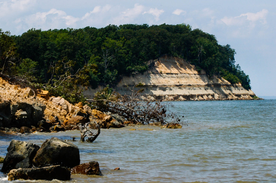
- Some geologists estimate that the Calvert County, Maryland, cliffs Captain John Smith explored in 1607, and 1608 have eroded back 300 feet. By the mid-1700s, forests were cut down and turned into farm fields, which increased erosion and caused sediment to fill some navigable rivers. Joppatowne, Maryland, was once a seaport but is now more than two miles from water.
- Many Chesapeake Bay islands that existed during colonial times are now severely eroded or completely submerged. In the early 1600s, Maryland’s Poplar Island encompassed several hundred acres. By the 1940s, only 200 acres remained. Today, the area is being restored using dredge material from Baltimore Harbor.