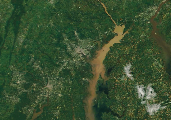
Scientists measure near-record river flow
2011 will likely be one of the highest annual flow years on record for the Susquehanna River due to wet weather.
Scientists with the U.S. Geological Survey (USGS) measured a near-record flow of 775,000 cubic feet per second (CFS) at Conowingo Dam on the Susquehanna River on the morning of Friday, Sept. 9. The river is expected to reach the third-highest flow in history this weekend, ranking behind the June 1972 flow of 1,130,000 cfs and the January 1996 flow of 909,000 cfs.

2011 will most likely be one of the highest annual flow years on record for the Susquehanna River due to wet spring weather and the September tropical storms Irene and Lee. High river flows are also being measured throughout other parts of the Bay watershed. (Visit the USGS’s real-time streamflow website for more information about the region’s river flows.)
Scientists expect that the sheer magnitude of the flood waters – which carry nutrient and sediment pollution from the land to the water – will have a negative effect on the Bay’s health. Some concerns and potential effects of the flooding include:
- Scouring of the Bay’s bottom, which can destroy next year’s crop of bay grasses.
- Smothering of oyster bars and other important hard-bottom habitats due to excess sediment flowing to the Bay.
- Drastic salinity changes as a flood of freshwater flows from rivers to the Bay.
- The release of nutrients, sediment and chemical contaminants that were previously trapped behind Conowingo Dam.
Timing makes a big difference in whether flood events have a short-term or long-term effect on the Bay’s health. Because these storms occurred in late summer, the Bay Program expects that there will be fewer long term impacts to the Bay ecosystem. September is the end of the peak growing season for bay grasses and is not a major spawning period for aquatic life. Additionally, cooler temperatures should prevent large algae blooms from growing in response to excess nutrient pollution.
It will take time for Bay Program partners to monitor and assess conditions before the true impact of the rain events is known. Maryland and Virginia are working closely with scientists from universities, the U.S. EPA and NOAA to expand monitoring of the Bay and its tidal rivers in the coming days and weeks. The USGS is working with the six Bay states, the District of Columbia and the Susquehanna River Basin Commission to measure nutrient and sediment pollution at key monitoring sites as part of the Bay Program’s non-tidal water quality monitoring network.
For more information about Chesapeake Bay monitoring and to get real-time monitoring data, visit the USGS Chesapeake Bay Activities website or Maryland’s Eyes on the Bay website.

Comments
There are no comments.
Thank you!
Your comment has been received. Before it can be published, the comment will be reviewed by our team to ensure it adheres with our rules of engagement.
Back to recent stories